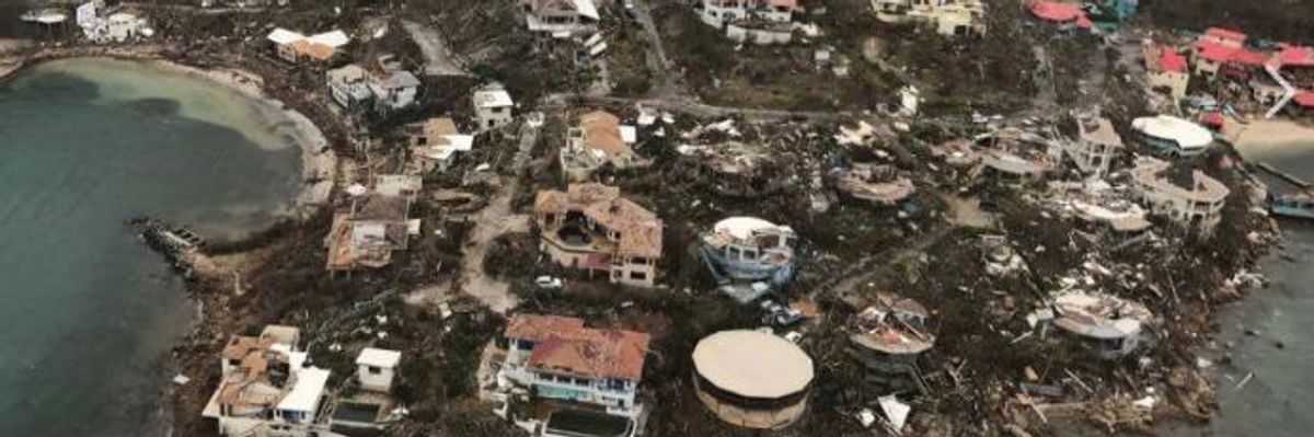
Severely damaged homes overlooking Leverick Bay on Virgin Gorda, British Virgin Islands. Photographs and video taken by Caribbean Buzz Helicopters, based in the Virgin Islands, show the scale of the devastation left by Hurricane Irma. (Photo: Caribbean Buzz Helicopters/Facebook)
Series of overhead videos offers look at power of storm and extent of damage across Caribbean isles
As Hurricane Irma continues on its "frightening" course towards the Keys and mainland Florida, a series of aerial videos taken from the Virgin Islands in the Caribbean are offering some of the first detailed looks at what the storm's wrath is capable of and the scale of the damage suffered from those exposed to her historic size and strength.
Providing by a tourism outfit called Caribbean Buzz Helicopters, based in the Virgin Islands, and posted to their Facebook page on Friday, the videos--as well as these photographs--offered some of the first overhead surveys of St. Thomas in the U.S. Virgin Islands (USVI), the islands of Eustatia and Tortala in the British Virginia Islands (BVI), including closeup looks at specific coastal communities and smaller islands hit by the storm throughout archipelago.
Bitter End, Virgin Gorda, BVI:
St. Thomas, USVI:
Tortola, BVI:
Eustatia, BVI:
Saba Rock, BVI:
Beef Island, BVI:
Cow Wreck, Anegada, BVI:
Mafolie, St. Thomas, USVI:
Our work is licensed under Creative Commons (CC BY-NC-ND 3.0). Feel free to republish and share widely.
As Hurricane Irma continues on its "frightening" course towards the Keys and mainland Florida, a series of aerial videos taken from the Virgin Islands in the Caribbean are offering some of the first detailed looks at what the storm's wrath is capable of and the scale of the damage suffered from those exposed to her historic size and strength.
Providing by a tourism outfit called Caribbean Buzz Helicopters, based in the Virgin Islands, and posted to their Facebook page on Friday, the videos--as well as these photographs--offered some of the first overhead surveys of St. Thomas in the U.S. Virgin Islands (USVI), the islands of Eustatia and Tortala in the British Virginia Islands (BVI), including closeup looks at specific coastal communities and smaller islands hit by the storm throughout archipelago.
Bitter End, Virgin Gorda, BVI:
St. Thomas, USVI:
Tortola, BVI:
Eustatia, BVI:
Saba Rock, BVI:
Beef Island, BVI:
Cow Wreck, Anegada, BVI:
Mafolie, St. Thomas, USVI: