

SUBSCRIBE TO OUR FREE NEWSLETTER
Daily news & progressive opinion—funded by the people, not the corporations—delivered straight to your inbox.
5
#000000
#FFFFFF
To donate by check, phone, or other method, see our More Ways to Give page.
Daily news & progressive opinion—funded by the people, not the corporations—delivered straight to your inbox.
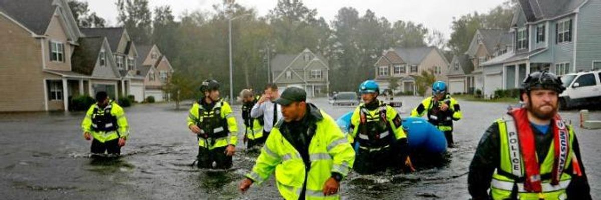
"Catastrophic and historic river flooding will continue for days across portions of the Carolinas," the National Weather Service warned in a Facebook post late Sunday. (Photo: David Goldman/AP)
After tearing through the Carolinas for several days, Hurricane Florence severely damaged tens of thousands of homes, killed over a dozen people, left nearly a million households without power, and unleashed thousands of cubic yards of toxic coal ash--and authorities are warning that the worst flooding from the storm is yet to come.
"For many (most?) places, the worst of Florence's flooding is still on the way," meteorologist Eric Holthaus noted in a tweet on Sunday. "Still expecting record or near-record flooding across a large part of North Carolina in the days to come."
\u201cCurrent flooding (left) vs flooding still to come (right).\n\nFor many (most?) places, the worst of Florence's flooding is still on the way. Still expecting record or near-record flooding across a large part of North Carolina in the days to come.\u201d— Eric Holthaus (@Eric Holthaus) 1537143385
While the National Hurricane Center on Sunday downgraded Florence to a tropical depression, the storm continues to dump heavy rain in North, South Carolina, and southwest Virginia, increasing the risk of landslides and additional damage.
"Catastrophic and historic river flooding will continue for days across portions of the Carolinas," the National Weather Service warned in a Facebook post late Sunday. "Florence is expected to produce heavy and excessive rainfall over the next couple of days. Portions of the Carolinas, mid-Atlantic states, and Southern New England are expected to receive an additional two to five inches of rain...with isolated maximum amounts of eight inches possible."
CNN meteorologist Michael Guy added: "The issue for the Carolinas then becomes the river flooding continuing for the rest of the week. All the rain that fell on the eastern flank of the Appalachians down into central portions of the state has to go somewhere. This water will flow downstream to areas already impacted from flooding rains from Florence. Thus, the rivers will take some time to recede."
\u201c645 am... Hurricane Florence estimated rainfall amounts from Thursday afternoon through Monday morning features a large area of 15 to 20 inches of rain across Wayne, Sampson and portions of Johnston County. #Florence #ncwx\u201d— NWS Raleigh (@NWS Raleigh) 1537181472
Videos and photos posted to social media depicting completely flooded freeways, homes half underwater, and buildings destroyed provide a glimpse of the immense scale of the devastation Florence has wrought across the Carolinas.
"The mammoth amounts of rain observed in southern North Carolina are virtually certain to eclipse anything measured in an East Coast tropical cyclone north of Florida," noted Bob Henson of the Weather Underground.
\u201cStoney Creek Plantation in Leland, NC on the Morgan Branch of Town Creek has devestating flooding from #HurricaneFlorence @JimCantore @StevePetyerak #ncwx\u201d— Charles Peek (@Charles Peek) 1537173572
\u201cFlooding from TD #Florence continues to worsen and expand across the heart of North Carolina. Sunday will be a rough day for NC\u2014and Florence's remnants still won't be done with the eastern U.S. https://t.co/BEmmPzpIRw\u201d— Weather Underground (@Weather Underground) 1537109764
\u201cNear NC 24 btw Kenansville and Beulaville.\u201d— Drew Brooks (@Drew Brooks) 1537127492
\u201cPlease RT! Avoid I-95: Drivers told to 'go around' North Carolina. These photos are from I-95 in Lumberton, NC, as of Sunday a.m. https://t.co/8G7SHfLvkj\u201d— WTVR CBS 6 Richmond (@WTVR CBS 6 Richmond) 1537114391
"The storm has never been more dangerous than it is now," North Carolina's Republican Gov. Roy Cooper said during a press conference on Sunday. "Many rivers are still rising, and are not expected to crest until later today or tomorrow."
Trump and Musk are on an unconstitutional rampage, aiming for virtually every corner of the federal government. These two right-wing billionaires are targeting nurses, scientists, teachers, daycare providers, judges, veterans, air traffic controllers, and nuclear safety inspectors. No one is safe. The food stamps program, Social Security, Medicare, and Medicaid are next. It’s an unprecedented disaster and a five-alarm fire, but there will be a reckoning. The people did not vote for this. The American people do not want this dystopian hellscape that hides behind claims of “efficiency.” Still, in reality, it is all a giveaway to corporate interests and the libertarian dreams of far-right oligarchs like Musk. Common Dreams is playing a vital role by reporting day and night on this orgy of corruption and greed, as well as what everyday people can do to organize and fight back. As a people-powered nonprofit news outlet, we cover issues the corporate media never will, but we can only continue with our readers’ support. |
After tearing through the Carolinas for several days, Hurricane Florence severely damaged tens of thousands of homes, killed over a dozen people, left nearly a million households without power, and unleashed thousands of cubic yards of toxic coal ash--and authorities are warning that the worst flooding from the storm is yet to come.
"For many (most?) places, the worst of Florence's flooding is still on the way," meteorologist Eric Holthaus noted in a tweet on Sunday. "Still expecting record or near-record flooding across a large part of North Carolina in the days to come."
\u201cCurrent flooding (left) vs flooding still to come (right).\n\nFor many (most?) places, the worst of Florence's flooding is still on the way. Still expecting record or near-record flooding across a large part of North Carolina in the days to come.\u201d— Eric Holthaus (@Eric Holthaus) 1537143385
While the National Hurricane Center on Sunday downgraded Florence to a tropical depression, the storm continues to dump heavy rain in North, South Carolina, and southwest Virginia, increasing the risk of landslides and additional damage.
"Catastrophic and historic river flooding will continue for days across portions of the Carolinas," the National Weather Service warned in a Facebook post late Sunday. "Florence is expected to produce heavy and excessive rainfall over the next couple of days. Portions of the Carolinas, mid-Atlantic states, and Southern New England are expected to receive an additional two to five inches of rain...with isolated maximum amounts of eight inches possible."
CNN meteorologist Michael Guy added: "The issue for the Carolinas then becomes the river flooding continuing for the rest of the week. All the rain that fell on the eastern flank of the Appalachians down into central portions of the state has to go somewhere. This water will flow downstream to areas already impacted from flooding rains from Florence. Thus, the rivers will take some time to recede."
\u201c645 am... Hurricane Florence estimated rainfall amounts from Thursday afternoon through Monday morning features a large area of 15 to 20 inches of rain across Wayne, Sampson and portions of Johnston County. #Florence #ncwx\u201d— NWS Raleigh (@NWS Raleigh) 1537181472
Videos and photos posted to social media depicting completely flooded freeways, homes half underwater, and buildings destroyed provide a glimpse of the immense scale of the devastation Florence has wrought across the Carolinas.
"The mammoth amounts of rain observed in southern North Carolina are virtually certain to eclipse anything measured in an East Coast tropical cyclone north of Florida," noted Bob Henson of the Weather Underground.
\u201cStoney Creek Plantation in Leland, NC on the Morgan Branch of Town Creek has devestating flooding from #HurricaneFlorence @JimCantore @StevePetyerak #ncwx\u201d— Charles Peek (@Charles Peek) 1537173572
\u201cFlooding from TD #Florence continues to worsen and expand across the heart of North Carolina. Sunday will be a rough day for NC\u2014and Florence's remnants still won't be done with the eastern U.S. https://t.co/BEmmPzpIRw\u201d— Weather Underground (@Weather Underground) 1537109764
\u201cNear NC 24 btw Kenansville and Beulaville.\u201d— Drew Brooks (@Drew Brooks) 1537127492
\u201cPlease RT! Avoid I-95: Drivers told to 'go around' North Carolina. These photos are from I-95 in Lumberton, NC, as of Sunday a.m. https://t.co/8G7SHfLvkj\u201d— WTVR CBS 6 Richmond (@WTVR CBS 6 Richmond) 1537114391
"The storm has never been more dangerous than it is now," North Carolina's Republican Gov. Roy Cooper said during a press conference on Sunday. "Many rivers are still rising, and are not expected to crest until later today or tomorrow."