
SUBSCRIBE TO OUR FREE NEWSLETTER
Daily news & progressive opinion—funded by the people, not the corporations—delivered straight to your inbox.
5
#000000
#FFFFFF
To donate by check, phone, or other method, see our More Ways to Give page.


Daily news & progressive opinion—funded by the people, not the corporations—delivered straight to your inbox.

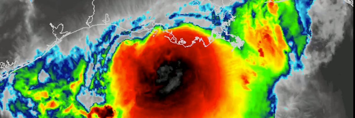
Infrared captures Hurricane Barry on Saturday morning ahead of making landfall. Barry was downgraded to a tropical storm after hitting the Louisiana coast. (Image: NWS Memphis, cc)
The climate crisis is making tropical storms worse, experts warned as Louisiana faced flooding threats from a powerful storm that made landfall Saturday at midday.
"The real increased threat from a warming climate is an atmosphere that's capable of producing higher intensity precipitation events," Jill Trepanier, an extreme climatic and weather events expert, told Al Jazeera on Friday.
\u201c#Barry made landfall as a hurricane early this afternoon near Intracoastal City, LA. Although the center is now over land, the rainfall threat is just beginning for many locations. Continue to follow updates at https://t.co/tW4KeGdBFb and https://t.co/SiZo8ozBbn\u201d— National Hurricane Center (@National Hurricane Center) 1563040970
Tropical storm Barry was downgraded from a hurricane after making landfall, but the threat from excessive rainfall and winds is still real for Louisiana residents in the cyclone's path.
Barry hit the Louisiana coast at about 1pm ET, drenching towns along the Gulf of Mexico with rainfall as it moved inland. Some parts of Louisiana could receive up to 25 inches of rain, according to some estimates.
\u201cCurrent conditions in Mandeville, LA as Hurricane Barry made landfall and now currently Tropical Storm Barry. \n\nPermission: Valkyrie Design, LLC\n@WeatherBug \n\n#HurricaneBarry #Barry #TSBarry #TropicalStormBarry #LAwx\u201d— Live Storm Chasers (@Live Storm Chasers) 1563042330
The city of New Orleans was under a shelter in place advisory Saturday. The Mississippi River, which threatened to overtop its levees after up to 10 inches of rain fell on the city Thursday, is no longer a threat to flood, but the city remains watchful.
The rainfall, studies show, is one of the major threats going forward of the climate crisis. As the weather warms the ocean, more water goes into the air--leading in turn to higher levels of precipitation.
"When the air is warmer, it can hold more water vapor," climatologist Mark Risser toldBuzzFeed News. "So that when a storm moves through an area that has warmer, wetter air, there's more of a source for the precipitation."
Risser, who wrote a study in 2017 about Hurricane Harvey's record rainfall for the science journal Geophysical Research Letters, has seen his predictions confirmed in subsequent studies. Barry's rainfall, climate researcher Katharine Hayhoe said in an email to BuzzFeed, is part of that trend.
"Barry appears to be playing out very much in the same direction, with the added impact of pre-storm flooding," said Hayhoe. "Though the formal attribution remains to be done, is likely related to the observed increase in heavy precipitation."
That, combined with Barry's slow movement, poses the real danger. Even after Barry, future such storms are expected to be at least as intense. The climate crisis will see to that, climate scientist Andrew Dessler toldReuters.
"We might have four or five times as much warming over the coming century as the last," said Dessler, "so these kinds of weather events are likely to get much, much worse."
Trump and Musk are on an unconstitutional rampage, aiming for virtually every corner of the federal government. These two right-wing billionaires are targeting nurses, scientists, teachers, daycare providers, judges, veterans, air traffic controllers, and nuclear safety inspectors. No one is safe. The food stamps program, Social Security, Medicare, and Medicaid are next. It’s an unprecedented disaster and a five-alarm fire, but there will be a reckoning. The people did not vote for this. The American people do not want this dystopian hellscape that hides behind claims of “efficiency.” Still, in reality, it is all a giveaway to corporate interests and the libertarian dreams of far-right oligarchs like Musk. Common Dreams is playing a vital role by reporting day and night on this orgy of corruption and greed, as well as what everyday people can do to organize and fight back. As a people-powered nonprofit news outlet, we cover issues the corporate media never will, but we can only continue with our readers’ support. |
The climate crisis is making tropical storms worse, experts warned as Louisiana faced flooding threats from a powerful storm that made landfall Saturday at midday.
"The real increased threat from a warming climate is an atmosphere that's capable of producing higher intensity precipitation events," Jill Trepanier, an extreme climatic and weather events expert, told Al Jazeera on Friday.
\u201c#Barry made landfall as a hurricane early this afternoon near Intracoastal City, LA. Although the center is now over land, the rainfall threat is just beginning for many locations. Continue to follow updates at https://t.co/tW4KeGdBFb and https://t.co/SiZo8ozBbn\u201d— National Hurricane Center (@National Hurricane Center) 1563040970
Tropical storm Barry was downgraded from a hurricane after making landfall, but the threat from excessive rainfall and winds is still real for Louisiana residents in the cyclone's path.
Barry hit the Louisiana coast at about 1pm ET, drenching towns along the Gulf of Mexico with rainfall as it moved inland. Some parts of Louisiana could receive up to 25 inches of rain, according to some estimates.
\u201cCurrent conditions in Mandeville, LA as Hurricane Barry made landfall and now currently Tropical Storm Barry. \n\nPermission: Valkyrie Design, LLC\n@WeatherBug \n\n#HurricaneBarry #Barry #TSBarry #TropicalStormBarry #LAwx\u201d— Live Storm Chasers (@Live Storm Chasers) 1563042330
The city of New Orleans was under a shelter in place advisory Saturday. The Mississippi River, which threatened to overtop its levees after up to 10 inches of rain fell on the city Thursday, is no longer a threat to flood, but the city remains watchful.
The rainfall, studies show, is one of the major threats going forward of the climate crisis. As the weather warms the ocean, more water goes into the air--leading in turn to higher levels of precipitation.
"When the air is warmer, it can hold more water vapor," climatologist Mark Risser toldBuzzFeed News. "So that when a storm moves through an area that has warmer, wetter air, there's more of a source for the precipitation."
Risser, who wrote a study in 2017 about Hurricane Harvey's record rainfall for the science journal Geophysical Research Letters, has seen his predictions confirmed in subsequent studies. Barry's rainfall, climate researcher Katharine Hayhoe said in an email to BuzzFeed, is part of that trend.
"Barry appears to be playing out very much in the same direction, with the added impact of pre-storm flooding," said Hayhoe. "Though the formal attribution remains to be done, is likely related to the observed increase in heavy precipitation."
That, combined with Barry's slow movement, poses the real danger. Even after Barry, future such storms are expected to be at least as intense. The climate crisis will see to that, climate scientist Andrew Dessler toldReuters.
"We might have four or five times as much warming over the coming century as the last," said Dessler, "so these kinds of weather events are likely to get much, much worse."