Seemingly loath to admit his erroneous claim that the state of Alabama would face a direct hit from Hurricane Dorian--the powerful storm that devastated the Bahamas in recent days and is now threatening the coasts of Florida, Georgia, and the Carolinas--President Donald Trump was again the subject of widespread online ridicule on Wednesday after he presented a government-generated map with Alabama additionally circled with a Sharpie pen.
In a tweet that rapidly gained over ten thousand likes and retweets, journalist Dennis Mersereau pointed out how obviously the map Trump pointed to during a White House statement was altered from the original:
As the Washington Post reports:
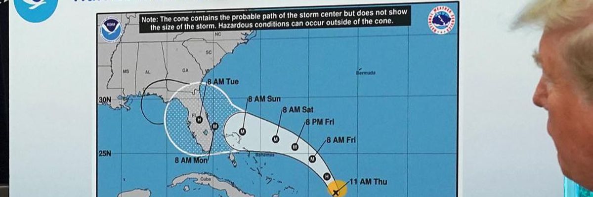
In a White House video released Wednesday, Trump displays a modified National Hurricane Center "Cone of Uncertainty" forecast, dated from 11 a.m. on Aug. 29, indicating Alabama would in fact be impacted. The graphic appears to have been altered with a Sharpie to indicate a risk the storm would move into Alabama from Florida.
"We had, actually, our original chart was that it was going to be hit -- hitting Florida directly," Trump said as he displayed the graphic from Aug. 29, which now includes an added appendage extending the cone into Alabama. "That was the original chart," Trump said. "It could've, uh, was going towards the Gulf," Trump explained in the video.
According to Mersereau, citing a U.S. statute, "It is a violation of federal law to falsify a National Weather Service forecast and pass it off as official, as President Trump did here."
Asked subsequently about the markings on the map, Trump told reporters he didn't know where the marks came from:
Last week, federal officials with the National Weather Service were forced to issue a public correction after Trump declared publicly that Alabama was at risk from the storm:
However, even after the NWS corrected the president's remarks, Trump did it again.
As video and photographs of the altered map spread on social media Wednesday--especially with the real storm wreaking extreme havoc from the Bahamas to the Carolinas--critics of the president unleashed over his self-indulgent, narcissistic focus on Alabama.