SUBSCRIBE TO OUR FREE NEWSLETTER
Daily news & progressive opinion—funded by the people, not the corporations—delivered straight to your inbox.
5
#000000
#FFFFFF
To donate by check, phone, or other method, see our More Ways to Give page.
Daily news & progressive opinion—funded by the people, not the corporations—delivered straight to your inbox.
"Hate to say, 'We told you so.'"
That comment came in a Monday tweet from climatologist Michael E. Mann, responding to a pair of meteorologists who noted the warm waters along the East Coast of the United States, which "means trouble for any tropical cyclones coming up the coast" for the next several weeks of the Atlantic hurricane season.
Mann, an atmospheric science professor at Penn State who directs the university's Earth System Science Center (ESSC), and other experts have warned that human-driven global heating that's warming the world's oceans is already causing and will continue to cause more intense and devastating tropical storms and hurricanes.
In April, Mann, ESSC scientist Daniel J. Brouillette, and alumnus Michael Kozar released their pre-season forecast for the 2020 North Atlantic hurricane season, which runs from the beginning of June to the end of November. They predicted a range of 15 to 24 named storms, with a "best estimate" of 20, for this year's season.
On Monday, Mann pointed out this was the first season in a decade for which they forecast up to 20 storms, then warned that "if anything, that might be too low..."
\u201cHate to say "we told you so".\n\nThis was the first Atlantic hurricane season in a decade where our pre-season (April) forecast called for as many as 20 named storms (likely range of 16 to 24): https://t.co/MNs6uv8m9r\nIf anything, that might be too low...\u201d— Prof Michael E. Mann (@Prof Michael E. Mann) 1595883934
\u201cThis means trouble for any tropical cyclones coming up the coast in the next 8 weeks...\u201d— Dan Satterfield (@Dan Satterfield) 1595883602
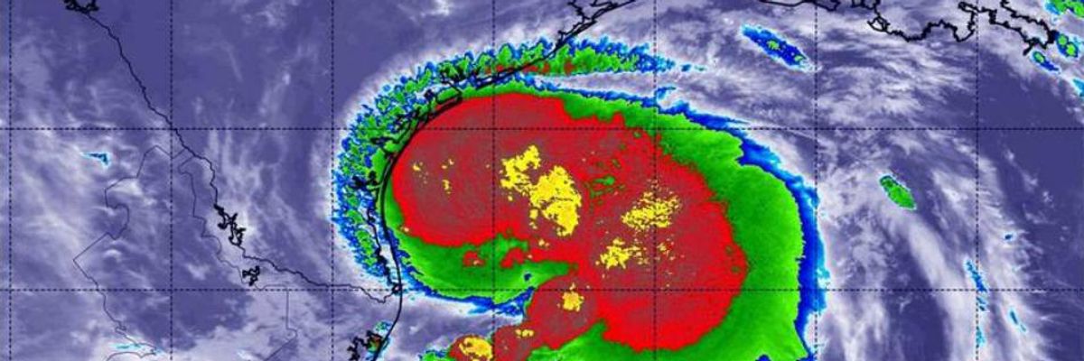
The fresh concerns from Mann and meteorologists Dan Satterfield and Eric Fisher came after the Category 1 Hurricane Hanna--the first hurricane and eighth named storm of this season--made landfall twice Saturday evening in southeast Texas, a region "already battered by the coronavirus pandemic," as the New York Timesnoted.
According to a weekend report from the Times:
The cities and counties in the path of Hanna are some of the same communities that have seen a sudden spike in Covid-19 cases and hospitalizations as Texas has become one of the largest hot spots in the country. In a state that is no stranger to bad weather, the typical hurricane-prep ritual was altered by social distancing and face coverings, with fever checks required to enter officials' news briefings, and sandbag distribution provided by workers who covered their faces in masks and bandannas.
The Texas Tribunereported Monday that thousands in the state remained without power as a result of Hanna. The National Hurricane Center (NHC) downgraded Hanna to a tropical storm early Sunday but also warned that "heavy rainfall, strong winds, storm surge, dangerous surf, and isolated tornadoes remain a threat from this system."
Late Tuesday morning, the NHC issued a potential tropical cyclone advisory for what could soon become the season's ninth named storm. Meteorologist Philip Klotzbach pointed out that the storm would be named Isaias and could set the record for the earliest ninth tropical cyclone in the Atlantic.
\u201cThe National #Hurricane Center is initiating advisories on Potential Tropical Cyclone 9 in the central tropical Atlantic. If it gets named, it would be #Isaias. The current record for earliest 'I' named storm in the Atlantic basin is Irene on August 7, 2005.\u201d— Philip Klotzbach (@Philip Klotzbach) 1595947610
Meteorologist and science writer Eric Holthaus also responded to the news in a series of tweets. "Heads up Puerto Rico and the Virgin Islands," he wrote of the ninth storm before noting that thousands of families in Puerto Rico, a U.S. territory, are still dealing with inadequate living conditions nearly three years after Hurricane Maria.
\u201cThousands of families are still without adequate housing in Puerto Rico -- THREE YEARS after Hurricane Maria.\n\n"tens of thousands of homes in Puerto Rico remain uninhabitable by modern standards, with damage ranging from total destruction to missing roofs"\nhttps://t.co/skTYFjgEv5\u201d— Eric Holthaus (@Eric Holthaus) 1595948691
"Tens of thousands of homes in Puerto Rico remain uninhabitable by modern standards, with damage ranging from total destruction to missing roofs," according to the Associated Press report from last week that Holthaus highlighted. "In the central mountain town of Villalba alone, 43 families still live under blue tarps as roofs."
NHC warned Tuesday that Isaias could hit Puerto Rico and various eastern Caribbean islands as early as Wednesday, bringing dangerous heavy rains, flash flooding, and mudslides. Although uncertainty remains over the storm's path, forecasters say it could reach the Bahamas on Saturday and Florida by Sunday.
Common Dreams is powered by optimists who believe in the power of informed and engaged citizens to ignite and enact change to make the world a better place. We're hundreds of thousands strong, but every single supporter makes the difference. Your contribution supports this bold media model—free, independent, and dedicated to reporting the facts every day. Stand with us in the fight for economic equality, social justice, human rights, and a more sustainable future. As a people-powered nonprofit news outlet, we cover the issues the corporate media never will. |
"Hate to say, 'We told you so.'"
That comment came in a Monday tweet from climatologist Michael E. Mann, responding to a pair of meteorologists who noted the warm waters along the East Coast of the United States, which "means trouble for any tropical cyclones coming up the coast" for the next several weeks of the Atlantic hurricane season.
Mann, an atmospheric science professor at Penn State who directs the university's Earth System Science Center (ESSC), and other experts have warned that human-driven global heating that's warming the world's oceans is already causing and will continue to cause more intense and devastating tropical storms and hurricanes.
In April, Mann, ESSC scientist Daniel J. Brouillette, and alumnus Michael Kozar released their pre-season forecast for the 2020 North Atlantic hurricane season, which runs from the beginning of June to the end of November. They predicted a range of 15 to 24 named storms, with a "best estimate" of 20, for this year's season.
On Monday, Mann pointed out this was the first season in a decade for which they forecast up to 20 storms, then warned that "if anything, that might be too low..."
\u201cHate to say "we told you so".\n\nThis was the first Atlantic hurricane season in a decade where our pre-season (April) forecast called for as many as 20 named storms (likely range of 16 to 24): https://t.co/MNs6uv8m9r\nIf anything, that might be too low...\u201d— Prof Michael E. Mann (@Prof Michael E. Mann) 1595883934
\u201cThis means trouble for any tropical cyclones coming up the coast in the next 8 weeks...\u201d— Dan Satterfield (@Dan Satterfield) 1595883602
The fresh concerns from Mann and meteorologists Dan Satterfield and Eric Fisher came after the Category 1 Hurricane Hanna--the first hurricane and eighth named storm of this season--made landfall twice Saturday evening in southeast Texas, a region "already battered by the coronavirus pandemic," as the New York Timesnoted.
According to a weekend report from the Times:
The cities and counties in the path of Hanna are some of the same communities that have seen a sudden spike in Covid-19 cases and hospitalizations as Texas has become one of the largest hot spots in the country. In a state that is no stranger to bad weather, the typical hurricane-prep ritual was altered by social distancing and face coverings, with fever checks required to enter officials' news briefings, and sandbag distribution provided by workers who covered their faces in masks and bandannas.
The Texas Tribunereported Monday that thousands in the state remained without power as a result of Hanna. The National Hurricane Center (NHC) downgraded Hanna to a tropical storm early Sunday but also warned that "heavy rainfall, strong winds, storm surge, dangerous surf, and isolated tornadoes remain a threat from this system."
Late Tuesday morning, the NHC issued a potential tropical cyclone advisory for what could soon become the season's ninth named storm. Meteorologist Philip Klotzbach pointed out that the storm would be named Isaias and could set the record for the earliest ninth tropical cyclone in the Atlantic.
\u201cThe National #Hurricane Center is initiating advisories on Potential Tropical Cyclone 9 in the central tropical Atlantic. If it gets named, it would be #Isaias. The current record for earliest 'I' named storm in the Atlantic basin is Irene on August 7, 2005.\u201d— Philip Klotzbach (@Philip Klotzbach) 1595947610
Meteorologist and science writer Eric Holthaus also responded to the news in a series of tweets. "Heads up Puerto Rico and the Virgin Islands," he wrote of the ninth storm before noting that thousands of families in Puerto Rico, a U.S. territory, are still dealing with inadequate living conditions nearly three years after Hurricane Maria.
\u201cThousands of families are still without adequate housing in Puerto Rico -- THREE YEARS after Hurricane Maria.\n\n"tens of thousands of homes in Puerto Rico remain uninhabitable by modern standards, with damage ranging from total destruction to missing roofs"\nhttps://t.co/skTYFjgEv5\u201d— Eric Holthaus (@Eric Holthaus) 1595948691
"Tens of thousands of homes in Puerto Rico remain uninhabitable by modern standards, with damage ranging from total destruction to missing roofs," according to the Associated Press report from last week that Holthaus highlighted. "In the central mountain town of Villalba alone, 43 families still live under blue tarps as roofs."
NHC warned Tuesday that Isaias could hit Puerto Rico and various eastern Caribbean islands as early as Wednesday, bringing dangerous heavy rains, flash flooding, and mudslides. Although uncertainty remains over the storm's path, forecasters say it could reach the Bahamas on Saturday and Florida by Sunday.