SUBSCRIBE TO OUR FREE NEWSLETTER
Daily news & progressive opinion—funded by the people, not the corporations—delivered straight to your inbox.
5
#000000
#FFFFFF
To donate by check, phone, or other method, see our More Ways to Give page.
Daily news & progressive opinion—funded by the people, not the corporations—delivered straight to your inbox.
The experts found five storms that would fit into their hypothetical category—and they have all happened since 2013.
Building on arguments and warnings that climate campaigners and experts have shared for years, a pair of scientists on Monday published a research article exploring the "growing inadequacy" of the Saffir-Simpson Hurricane Wind Scale and possibly adding a Category 6.
Global heating—driven by human activities, particularly the extraction and use of fossil fuels—is leading to stronger, more dangerous storms that are called hurricanes in the North Atlantic and Northeast Pacific, typhoons in the Northwest Pacific, and tropical cyclones in the South Pacific and Indian oceans.
The Saffir-Simpson scale "is the most widely used metric to warn the public of the hazards" of such storms, Michael Wehner of Lawrence Berkeley National Laboratory and James Kossin of the First Street Foundation explained in their new paper, published in Proceedings of the National Academy of Sciences.
"There haven't been any in the Atlantic or the Gulf of Mexico yet but they have conditions conducive to a Category 6, it's just luck that there hasn't been one yet."
"Our motivation is to reconsider how the open-endedness of the Saffir-Simpson scale can lead to underestimation of risk, and, in particular, how this underestimation becomes increasingly problematic in a warming world," Wehner said in a statement.
The scale is: Category 1 (74-95 mph); Category 2 (96-110 mph); Category 3 (111-129 mph); Category 4 (130-156 mph); and Category 5 (greater than 157 mph). Wehner and Kossin considered creating a Category 6 for storms with sustained winds of at least 192 mph.
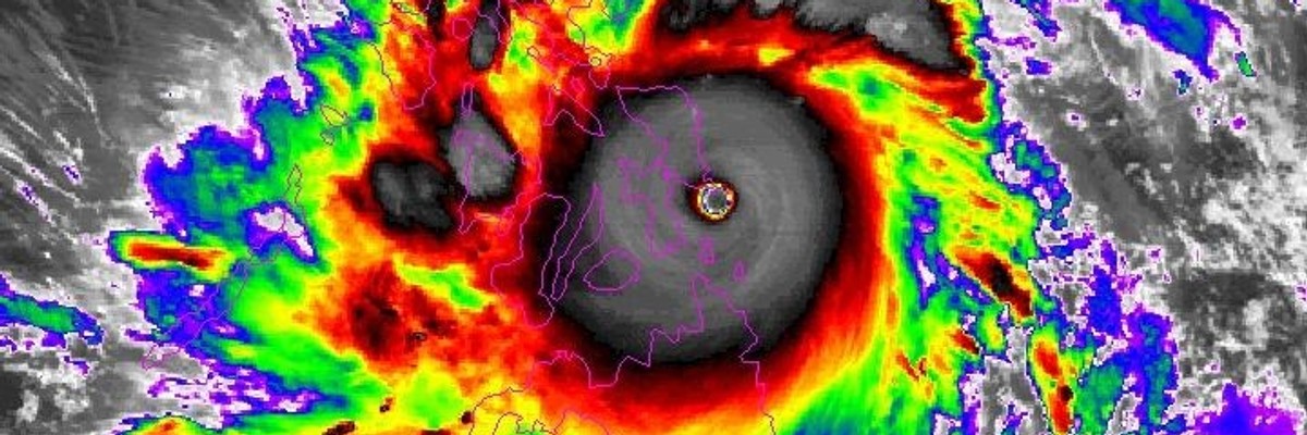
The pair found five storms that would fit into their Category 6: Typhoon Haiyan in 2013, Hurricane Patricia in 2015, Typhoon Meranti in 2016, Typhoon Goni in 2020, and Typhoon Surigae in 2021.
"The most intense of these hypothetical Category 6 storms, Patricia, occurred in the Eastern Pacific making landfall in Jalisco, Mexico, as a Category 4 storm," the paper notes. "The remaining Category 6 storms all occurred in the Western Pacific."
"Two of them, Haiyan and Goni, made landfall on heavily populated islands of the Philippines. Haiyan was the costliest Philippines storm and the deadliest since the 19th century, long before any significant warning systems," the paper continues.
The 2013 storm killed at least 6,300 people in the Philippines and left millions more homeless.
"There haven't been any in the Atlantic or the Gulf of Mexico yet but they have conditions conducive to a Category 6, it's just luck that there hasn't been one yet," Wehner toldThe Guardian. "I hope it won't happen, but it's just a roll of the dice. We know that these storms have already gotten more intense, and will continue to do so."
As the paper details, the pair found that "the Philippines, parts of Southeast Asia, and the Gulf of Mexico are regions where the risk of a Category 6 storm is currently of concern. This risk near the Philippines is increased by approximately 50% at 2°C above preindustrial and doubled at 4°C. Increased risk Category 6 storms in the Gulf of Mexico increases even more, doubling at 2°C above preindustrial and tripling at 4°C."
Governments worldwide have signed on to the Paris agreement, which aims to keep global temperature rise this century below 2°C, with a more ambitious target of 1.5°C, but scientists stress that policymakers are crushing hopes of meeting either goal.
Wehner said that "even under the relatively low global warming targets of the Paris agreement... the increased chances of Category 6 storms are substantial in these simulations."
The scientists considered what the addition of a Category 6 could look like, but they aren't necessarily advocating for it. Kossin said in a statement that "tropical cyclone risk messaging is a very active topic, and changes in messaging are necessary to better inform the public about inland flooding and storm surge, phenomena that a wind-based scale is only tangentially relevant to."
"While adding a sixth category to the Saffir-Simpson Hurricane Wind Scale would not solve that issue, it could raise awareness about the perils of the increased risk of major hurricanes due to global warming," he continued. "Our results are not meant to propose changes to this scale, but rather to raise awareness that the wind-hazard risk from storms presently designated as Category 5 has increased and will continue to increase under climate change."
The Washington Post on Monday also emphasized the need for improved communication about flooding and storm surge:
National Oceanic and Atmospheric Administration research shows such water-related hazards are hurricanes' deadliest threats, said Deirdre Byrne, a NOAA oceanographer who studies ocean heat and its role in hurricane intensification. While adding a Category 6 "doesn't seem inappropriate," she said, combining the Saffir-Simpson scale with something like an A through E rating for inundation threats might have a greater impact.
"That might save even more lives," Byrne said.
In a statement, National Hurricane Center Director Michael Brennan seconded those concerns. He said NOAA forecasters have "tried to steer the focus toward the individual hazards," including storm surge, flooding rains, and dangerous rip currents, rather than overemphasizing the storm category, and, by extension, the wind threats alone.
"It's not clear that there would be a need for another category even if storms were to get stronger," he said.
Even if the center has no plans to expand the wind scale, "talking about hypothetical Category 6 storms is a valuable communication strategy for policymakers and the public," former NOAA hurricane scientist Jeff Masters wrote Monday, "because it is important to understand how much more damaging these new superstorms can be."
Political revenge. Mass deportations. Project 2025. Unfathomable corruption. Attacks on Social Security, Medicare, and Medicaid. Pardons for insurrectionists. An all-out assault on democracy. Republicans in Congress are scrambling to give Trump broad new powers to strip the tax-exempt status of any nonprofit he doesn’t like by declaring it a “terrorist-supporting organization.” Trump has already begun filing lawsuits against news outlets that criticize him. At Common Dreams, we won’t back down, but we must get ready for whatever Trump and his thugs throw at us. Our Year-End campaign is our most important fundraiser of the year. As a people-powered nonprofit news outlet, we cover issues the corporate media never will, but we can only continue with our readers’ support. By donating today, please help us fight the dangers of a second Trump presidency. |
Building on arguments and warnings that climate campaigners and experts have shared for years, a pair of scientists on Monday published a research article exploring the "growing inadequacy" of the Saffir-Simpson Hurricane Wind Scale and possibly adding a Category 6.
Global heating—driven by human activities, particularly the extraction and use of fossil fuels—is leading to stronger, more dangerous storms that are called hurricanes in the North Atlantic and Northeast Pacific, typhoons in the Northwest Pacific, and tropical cyclones in the South Pacific and Indian oceans.
The Saffir-Simpson scale "is the most widely used metric to warn the public of the hazards" of such storms, Michael Wehner of Lawrence Berkeley National Laboratory and James Kossin of the First Street Foundation explained in their new paper, published in Proceedings of the National Academy of Sciences.
"There haven't been any in the Atlantic or the Gulf of Mexico yet but they have conditions conducive to a Category 6, it's just luck that there hasn't been one yet."
"Our motivation is to reconsider how the open-endedness of the Saffir-Simpson scale can lead to underestimation of risk, and, in particular, how this underestimation becomes increasingly problematic in a warming world," Wehner said in a statement.
The scale is: Category 1 (74-95 mph); Category 2 (96-110 mph); Category 3 (111-129 mph); Category 4 (130-156 mph); and Category 5 (greater than 157 mph). Wehner and Kossin considered creating a Category 6 for storms with sustained winds of at least 192 mph.
The pair found five storms that would fit into their Category 6: Typhoon Haiyan in 2013, Hurricane Patricia in 2015, Typhoon Meranti in 2016, Typhoon Goni in 2020, and Typhoon Surigae in 2021.
"The most intense of these hypothetical Category 6 storms, Patricia, occurred in the Eastern Pacific making landfall in Jalisco, Mexico, as a Category 4 storm," the paper notes. "The remaining Category 6 storms all occurred in the Western Pacific."
"Two of them, Haiyan and Goni, made landfall on heavily populated islands of the Philippines. Haiyan was the costliest Philippines storm and the deadliest since the 19th century, long before any significant warning systems," the paper continues.
The 2013 storm killed at least 6,300 people in the Philippines and left millions more homeless.
"There haven't been any in the Atlantic or the Gulf of Mexico yet but they have conditions conducive to a Category 6, it's just luck that there hasn't been one yet," Wehner toldThe Guardian. "I hope it won't happen, but it's just a roll of the dice. We know that these storms have already gotten more intense, and will continue to do so."
As the paper details, the pair found that "the Philippines, parts of Southeast Asia, and the Gulf of Mexico are regions where the risk of a Category 6 storm is currently of concern. This risk near the Philippines is increased by approximately 50% at 2°C above preindustrial and doubled at 4°C. Increased risk Category 6 storms in the Gulf of Mexico increases even more, doubling at 2°C above preindustrial and tripling at 4°C."
Governments worldwide have signed on to the Paris agreement, which aims to keep global temperature rise this century below 2°C, with a more ambitious target of 1.5°C, but scientists stress that policymakers are crushing hopes of meeting either goal.
Wehner said that "even under the relatively low global warming targets of the Paris agreement... the increased chances of Category 6 storms are substantial in these simulations."
The scientists considered what the addition of a Category 6 could look like, but they aren't necessarily advocating for it. Kossin said in a statement that "tropical cyclone risk messaging is a very active topic, and changes in messaging are necessary to better inform the public about inland flooding and storm surge, phenomena that a wind-based scale is only tangentially relevant to."
"While adding a sixth category to the Saffir-Simpson Hurricane Wind Scale would not solve that issue, it could raise awareness about the perils of the increased risk of major hurricanes due to global warming," he continued. "Our results are not meant to propose changes to this scale, but rather to raise awareness that the wind-hazard risk from storms presently designated as Category 5 has increased and will continue to increase under climate change."
The Washington Post on Monday also emphasized the need for improved communication about flooding and storm surge:
National Oceanic and Atmospheric Administration research shows such water-related hazards are hurricanes' deadliest threats, said Deirdre Byrne, a NOAA oceanographer who studies ocean heat and its role in hurricane intensification. While adding a Category 6 "doesn't seem inappropriate," she said, combining the Saffir-Simpson scale with something like an A through E rating for inundation threats might have a greater impact.
"That might save even more lives," Byrne said.
In a statement, National Hurricane Center Director Michael Brennan seconded those concerns. He said NOAA forecasters have "tried to steer the focus toward the individual hazards," including storm surge, flooding rains, and dangerous rip currents, rather than overemphasizing the storm category, and, by extension, the wind threats alone.
"It's not clear that there would be a need for another category even if storms were to get stronger," he said.
Even if the center has no plans to expand the wind scale, "talking about hypothetical Category 6 storms is a valuable communication strategy for policymakers and the public," former NOAA hurricane scientist Jeff Masters wrote Monday, "because it is important to understand how much more damaging these new superstorms can be."